INDAVER WASTE FACILITY AT RINGASKIDDY
STRATEGIC INFRASTRUCTURE DEVELOPMENT
APPLICATION TO AN BORD PLEANÁLA
REG. NO. 04.PA0045
BRIEF OF EVIDENCE
APRIL 2015
MARCIA K. D’ALTON B.E., M.ENG.SC.
MEMBER, CORK COUNTY COUNCIL
My name is Marcia D’Alton.
I am a resident of Cork Harbour. My family and I currently live in Passage West. We formerly lived in Monkstown. I have sailed in Cork Harbour all my life and have been a member of Monkstown Bay Sailing Club for many years. I have five children, all of whom live beside, sail in and love Cork Harbour.
I hold a Bachelors Degree in Engineering and a Masters Degree of Engineering Science from University College Cork. I have worked as an environmental consultant specialising in the fields of treatment and management of non-hazardous, agricultural and sludge wastes, nutrient management, renewable energy development, catchment water quality management, waste water treatment, the licensing and permitting of waste handling facilities and Integrated Pollution Control licensing. I completed projects in these areas for a range of clients, including local authorities, the Department of the Environment, Heritage and Local Government, the UK Department of the Environment and Rural Development, the North/South Ministerial Council, the European Commission, private industry and community groups.
I was an elected member of Passage West Town Council for 10 years. The jurisdiction of Passage West Town Council encompasses the three harbourside towns of Passage West, Glenbrook and Monkstown. One of my key focus areas during my term as elected member of the Town Council was to capitalise on the relationship between these towns and the harbour. Through the Town Council, I have delivered presentations on the special architecture of Passage West and Monkstown, sought funding, researched and designed trails and noticeboards for interpretation of heritage and introduced the theme of Maritime Heritage as a brand for Passage West. I collaborated with several departments within Cork County Council and larger developers with an interest in the towns to achieve a common goal for new development to complement and enhance the valuable assets of our harbourside towns. I represented Passage West Town Council on the Advisory Group of the Cork Harbour Forum.
In May 2014, I was elected to Cork County Council. Since then I have been invited to deliver several lectures on both local government and planning to postgraduate students of University College Cork. In my capacity as county councillor, I represent over 70,000 people living in the Ballincollig-Carrigaline Municipal District.
This is the harbour area of Ontario, Canada. Here is the confluence of Kingston Harbour and a second natural harbour at the mouth of the Cataraqui River. Fort Henry is a 19th century military fort built on Point Henry, a strategic elevated point close to the mouth of the Cataraqui River where it flows into the St. Lawrence River at the east end of Lake Ontario. In the 19th century, this was British territory.

The original fort was constructed in 1812 to protect the Kingston Royal Naval Dockyard on Point Frederick from possible American attack and to protect the Rideau Canal upstream. The earlier fort was repla ced by a much finer structure, the building of which began in 1832 and was finished by 1840. The fort was garrisoned by units of the British Army until 1870 and subsequently by Canadian forces. Although Fort Henry has never seen military action, it was used as a prison in 1837/38 and during the first and second World Wars.
Fort Henry was designated a National Historic Site of Canada in 1923. But it does not stand alone.  Fort Frederick stands on what are now the grounds of the Royal Military College of anada. It is a fortcomprising earthworks surrounding a Martello Tower, the construction of which da
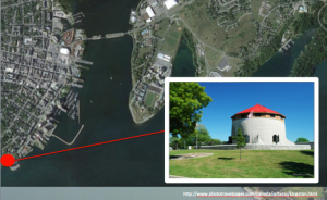 tes from 1846. The Murney Tower was also built in 1846. Constructed of limestone, it is surrounded by a dry ditch and is accessible only by drawbridge. Shoal Tower is directly opposite Kingston City Hall. Built in
  1847, it is a Marte
 llo Tower, 11 metres high and 16.5 metres in diameter. The Cathcart Tower is located on Cedar Island and protected the eastern approaches of Kingston Harbour. It is also a limestone tower, of similar dimensions to the Shoal Tower and also surrounded by a dry ditch and glacis.
Even the unimaginative can see the parallels between the fortifications of Cork’s Lower Harbour and those of Kingston Harbour. Like Fort Henry, the first Fort Westmoreland was built on Spike Island in the 1770s during the same decade as the British moved the Royal Navy base from Kinsale to Cork Harbour. The first Fort Westmoreland was completed in 1779 and, coupled with the building of  a small fort at Cobh, strengthened the harbour’s defences.
It took little time for the British to realise the strategic significance of Spike Island and so they decided to replace the  original fort with a much larger structure. The foundation stone for the Fort Westmoreland that we know today was laid in 1804. The battery at Cobh was brought back into service. Storehouses and buildings were constructed on Haulbowline Island to serve the Royal Navy. Powder magazines were built on Rocky Island. Although fortifications had
  been on the western headland at the entrance to Cork Harbour since the mid-1500s and on the eastern headland since the early 1600s, they were modified and reconstructed to become the Fort C
 amden and Fort Carlisle that we know today. From 1813 – 1815, two Martello Towes were built to work with the Lower
  Harbour forts in protecting enemy entry from the sea. The smaller of these is on Haulbowline Island. The larger is on the headland at Ringaskiddy.
So in both Lower Cork Harbour and in Kingston Harbour, five very fine 19th century British built fortifications survive until today.
 Where the Cork Harbour situation differs from the Kingston Harbour situation is that the fortifications of Cork Harbour do not end just there. Three more Martello Towers were built on the northern side of the Great Island, one at
  Marino Point, another at Belvelly and the third at Rostellan. All are in the same style of those built in the Lower Harbour but all are smaller than the Ringaskiddy tower. To complement the coastal defences, a new barracks was built on the high ground to the north of
  Cork City and a gunpowder mills and adjacent artillery barracks was built at Ballincollig.
The other very unfortunate difference between the Canadian and Cork Harbour situations is the success with which their relics of the 19th century have been celebrated and capitalised on. The Kingston Fortifications, centred on Fort Henry, are a tremendously successful tourism offering. Fort Henry is administered by Parks Canada and operated by the St. Lawrence Parks C ommission. Uniformed military interpreters staff the fort and conduct demonstrations of British military life and tours for visitors. Self guided tours are also available.
Fort Henry was designated a national historic site of Canada in 1923. But over time, realisation dawned amongst the Canadian authorities that Fort Henry was designated not just for its magnificent construction or for its scenic location but for its function as a defence of Kingston Harbour. And Fort Henry could not function on its own. It was merely one part of a whole. So in 1989, all five structures each became a part of the broader Kingston Fortifications National Historic Site of Canada. In 2007, the collection of five Kingston fortifications were included in the designation of the Rideau Canal as a UNESCO World Heritage Site.
 Forts Camden and Carlisle and both the Ringaskiddy and Haulbowline Martello Towers are all individually included on the Record of Protected Structures, as are the associated military stores on Rocky and Haulbowline Islands. The whole of Spike Island has been designated a national monument. Critically, the intervisibility between them has not received statutory protection.
The Ringaskiddy Martello Tower is worth preserving for its own sake. Worldwide, 120 of 220 Martello Towers built around the world are still standing. Of that 120, 52 lie unused and/or derelict. At this stage, Mr. Inspector, I refer you to my evidence to the previous oral hearing delivered on 5th May 2009. As part of this evidence, I examined every single one of those Martello Towers. In this regard, I refer you to Section 4, page 6 which details the Martello Towers built in England, Sections 5.1 and 5.2 which detail the Martello Towers of North and South Dublin respectively, Section 5.4 which looks at Martello Towers built in Ireland locations other than Counties Dublin and Cork and Section 6 which examines the construction and current state of Martello Towers in Scotland, Jersey and Guernsey, Spain and the Mediterranean, Canada, South Africa, Mauritius, Sierra Leone, the Carribean Islands, Bermuda, Asia and Australia. I also direct you to Section 5.3 which details the Martello Towers in County Cork, including those in Cork Harbour.
I will, however, paraphrase Section 7 of my 2009 evidence because of its ongoing tremendous relevance:
“The Ringaskiddy Martello Tower is the only Martello Tower in Ireland to stand in a moat with surrounding glacis. One of the four towers on Bere Island, the Cathcart Tower, also sat in a moat. However, the Cathcart Tower disappeared before the beginning of the 20th century. Of the 120 Martello Towers remaining worldwide, 12 stand in a moat. In three of those 12, the moat has been at least partially destroyed. Of the remaining nine towers, five are in acutely poor condition. One is in private ownership and is used as a domestic dwelling. Two others are publicly accessible and in good condition. One is the Victoria Tower in Jersey; the other is the Ferry Point Tower in Bermuda. Both were built in a design similar to the south coast of England towers. Neither has vertical walls, as does the Ringaskiddy Tower. Both are considerably smaller than the Ringaskiddy Tower: the Victoria Tower is 32 ft in diameter and 33 ft high, while the Ferry Point Tower is elliptical with a maximum diameter of 39 ft and is 34 ft high. We have already noted the Ringaskiddy Tower to be 51 ft in diameter and 40 ft high. Equally, the Victoria Tower was designed to take one 24 pdr gun, while the Bermudan Ferry Point Tower carried one 18 pdr gun. The Ringaskiddy Tower was designed to take two 24 pdr guns. So today, the Ringaskiddy Tower is the largest Martello Tower of any reasonable condition standing in an original moat in the world.”


So as its own integral structure, the Ringaskiddy Martello Tower is precious and worth preserving.
Of the 52 Martello Towers built in Ireland in the 19th century, only four had paths associated with them. Two of these were on Bere Island and connected the towers to their respective batteries. The other two were the Ringaskiddy and Rossleague Towers in Cor k Harbour. The path at Rossleague led from the tower to the nearby quayside. The path at the Ringaskiddy tower led to Gobby Beach.
It was always intended that there would be a path from the Ringaskiddy Martello Tower. This colour sketch map is MPH1 197, now held in the Public Records Office in Kew, London. It outlines the intention of the British army to purchase the ground on which the Martello Tower was built. The annotations give a sense of the  significance with which the British military regarded the strategic nature of the Ringaskiddy peninsula. This letter was dated 1811. The site was purchased in 1812.
A subsequent survey in 1859, long after the tower was built,  indicates precisely that which we should now regard as the curtilage of this Martello Tower. Its extent was marked by ordnance stones, highlighted in red here, as was the general 19th century practice in delineating military ground. I quote from page 23 of my 2009 evidence:
“In the case of the Ringaskiddy Martello Tower, the limit of the military ground was marked by 10 ordnance stones. The glacis around the tower extended to the limit of the site and was marked by six ordnance stones. The fifth and sixth performed a dual function in also marking the beginning of the path between the tower and Gobby Beach. Two mor e ordnance stones marked the line of the path mid-way as it descended down Ringaskiddy Hill, while the ninth and tenth ordnance stones marked its end at Gobby Beach. Several of these ordnance stones are still evident around the Martello Tower, including those marking the beginning of the access path.”
According to the 1859 survey, the path between the tower and Gobby Beach was bounded on either side by a sod ditch. This ditch  has not survived the passage of time. Section 14.3.5.1 of the EIS says that the partial line of a path is evident in aerial photographs but is not apparent on the ground. This is not the case. There is little doubt but that a raised and linear section of
  ground in the field below the Martelo Tower is indeed the remains of the original path. It is directly in line with ordnance stones 4
and 9 and that point on Spike Island opposite which the Martello Tower path ended. A small section has sporadic gorse bushes growing on it but there is little doubt that it is the remnants of the same path.
To be fair, perhaps the EIS meant that it is not evident on the ground within the site of the proposed Indaver facility. That is true. The site is so overgrown that it would be a very brave job to investigate underneath the gorse and brambles. The EIS is correct in noting that  some remnants of a path through the site of the proposed development are clearly visible in a 2005 Ordnance Survey aerial photograph. There has been no ground disturbance on the site since so if that path is no longer evident in more recent aerial photographs, the culprit is overgrowth rather than human destruction.
Building over the line of this path truly constitutes heritage destruction. So what happens if planning permission is granted? The  gorse and overgrowth will be taken back. Pre-development archaeological investigations will begin. What if evidence of the path is found? Section 14.6.1 of the EIS tells us that any archaeological features identified during these investigations will be “resolved to professional standards of archaeological practice”. What does this mean? The EIS tells us that the material will be preserved in situ or by record. With a waste to energy plant being constructed directly on top of it, it would be difficult to preserve the 19th century path in situ. So we can only assume it will be preserved by record. That is worse than derisory treatment of a path within the curtilage of a recorded monument.
But this is only one element of the potential destruction the proposed waste to energy facility would wreak on the Martello Tower. Section 3.4.2 of the Department of Arts, Heritage and the Gaeltacht’s Architectural Design Guidelines7 tells us that:
“the contribution of setting to the character of the architectural heritage should not be underestimated … The location of a structure may have been designed to relate to a particular landscape feature”.
Section 13.2.1 of the Guidelines7 contributes further to our understanding of the significant relationship between the Ringaskiddy peninsula and the Martello Tower structure itself:
“The attendant grounds of a structure are lands outside the curtilage of the structure but which are associated with the structure and are intrinsic to its function, setting and/or appreciation”.
The Martello Tower was designed and constructed to stand proud over Cork Harbour, to keep a watchful eye for and to defend the harbour from the approach of unwanted intruders. It couldn’t do this from down in a hole. It couldn’t do it from the proposed Indaver site. It couldn’t do it from Ringaskiddy village. It was built on the top of the peninsula because it needed to be in an elevated location beside the sea. The critical nature of its location is clear from the annotation on Lieutenant-Colonel Henwick’s document of 1811. He said:
“this height … is deemed an important position”.
There is little doubt but that the hill of the Ringaskiddy peninsula is intrinsic to the function of the Martello Tower. There is little doubt but that it could not function in any other setting. Equally, should the setting be altered, appreciation of that function would be significantly diminished. Based on the advice from the Department7, there can be little argument but that the Ringaskiddy peninsula is the attendant grounds for the Ringaskiddy Martello Tower.
To be fair, the EIS does not underplay the damage the proposed waste-to-energy facility would have on the setting of the Martello Tower. Section 14.5.1.4 discusses visual impact on architectural heritage. It clearly states:
“The view towards the Martello Tower will be altered by the construction of the waste to energy facility. It is currently a visually prominent feature on the peninsula … the construction of the large scale industrial complex which forms the waste to energy facility will diminish the prominence of the tower and alter its setting in the landscape … The modification of this to an industrial setting, elements of which protrude above the ridgeline of the peninsula will significantly alter the landscape of the monument.”
Nonetheless, this statement contrasts starkly with the County Development Plan’s stated objectives for protection of architectural heritage. Objective HE 4-1 (e) has an aim to:
“Protect the curtilage and attendant grounds of all structures included in the Record of Protected Structures”
whilst Objective HE 4-1(f) has as its stated aim:
“To ensure that development proposals are appropriate in terms of architectural treatment, character, scale and form to the existing protected structure and not detrimental to the special character and integrity of the protected structure and its setting”.
We are told that attempts have been made to minimise the impact of the proposed process building with variations in the colour of the proposed cladding. Section 1.2.3 of the EIS tells us how the 2008 proposal had a footprint of more than 14,000 m2 whilst this current proposal has a footprint of less than 9,300 m2. One of the reasons the Senior Planner cites for the project’s acceptability is its “reduced  size when compared to the previous application”. But footprint is irrelevant, unless one is flying over the site. What is critical is height and in fact this 2016 proposal is higher than the 2008 proposal. In 2008, the process building was indicated in the EIS as
  being 42.5 metres high, which was actually 48.277 metres OD. This proposal, regardless of Indaver’s attempts to dig it down into the ground, is actually 50.7 metres OD. So to the viewer, the waste to energy process building has got bigger, not smaller.
It is not possible to integrate something that is just too big into a site that is just too small. The design’s signature failure in this regard is reflected in comments from Cork County Council’s Archaeological Officer when she speaks of the “sheer scale of the complex, the blocky nature of the design especially the tall central tower which breaks the sky line from a number of aspects”. She continues to express concern about “the blocky design and scale of the proposed development [which] visually detracts from the setting of the Martello … The design does not sit comfortably in the landscape and the height of the proposed facility especially the central block impact on the setting of the Martello Tower”.
Similarly, the County Architect describes the “immense scale” of the proposed building, its potential to visually “dominate” the landscape, the proposal’s “enormous size” and critically, that the “scale of this proposal is out of proportion relative to its sensitive location”.
Little wonder that Section 14.7.1 of the EIS leaves little doubt as to the ultimate residual impact of the proposed process building:
“The view of the Martello Tower from within the harbour and surrounding landscape will be altered. Its position of prominence on the Ringaskiddy peninsula will be diminished by the large scale nature of the industrial facility and the greenfield setting of the tower will become more industrialised in nature.”
Section 14.6.2 of the EIS suggests that the proposed “amenity” walkway from Gobby Beach to behind the Indaver site will enhance access to the Martello Tower by providing a formal route through the Indaver lands. I would like to clarify that this assertion could not be further from reality.

This is the landscape drawing of the proposed path provided in the EIS. It cannot hide the pylons on one side, under which one would be forced to walk . It illustrates pretty trees and bushes on the other, deliberately planted to camouflage the Indaver buildings. But strategically, the drawing does not show what lies beyond those pretty trees and bushes. This is the vista enjoyed currently enjoyed when climbing the Ringaskiddy hill to visit the

Martello Tower. The view from the “amenity” path proposed by Indaver would look something akin to this. Construction of the proposed waste 
facility would result in complete less of the existing breathtaking vista over three points of the compass and would create an industrial environment, bounded by pylons on one side and overwhelmingly to process buildings on the other.
This destruction of sense of place diametrically opposes Mr. Kelly’s opinion of the “sensitive” approach taken to designing the facility. He tells us in Section 11.7 of the EIS that:
“The development has been sensitively designed in relation to the Martello Tower protected structure in order to retain its prominence when viewed from around the harbour”.
Mr. Kelly’s evidence predicts that the visual effects of the proposed waste to energy facility would be “generally within a 0.5 km radius of the site from the north, east and south”. That sounds like three quarters of the compass to me. Again, his assessment is clearly opposed to that of the County Architect, who felt:
“Photomontages indicate that the building will have a visual impact from virtually the entire harbour area and particularly from entering the harbour and from Cobh (cathedral) and Monkstown and adjacent areas”.
It is not the first time that Mr. Kelly’s assessment differs from that of the people of Cork Harbour. Mr. Kelly tells us that his experience encompasses the visual impact assessment, site development strategies and master planning of other energy-related infrastructure including the Bord Gáis Whitegate Combined Cycle Gas Turbine power station. Planning permission for this €400 million development was submitted in 2006 (Cork County Council Planning Ref: 06/10126 and 07/13433). This was a project for which Eirgrid had defined a national need. Not merely was the electricity going to be necessary into the future but the proposed power station would address security of supply and price competition issues. A suitable location was sought in the Cork Harbour area and Whitegate was chosen as being an industrial zoned area, located in close proximity to gas and electricity grids, with ready access to a secondary fuel supply. From an environmental point of view, the location was optimal because steam from the proposed power plant would be used by the refinery. Sound familiar?
The Environmental Impact Statement produced for the project by Arup described the visual impact of the proposed plant from various vantage points in the harbour. It described the existing landscape character as being defined by the existing refinery and so there would be “no significant alteration to the landscape”. It produced photomontages from vantage points all around the harbour to indicate that this was indeed the case. In particular, the view from Roches Point (above) was deemed to have no significant visual impact, although there would be views with slight negative visual impact from the roads over the Roches Point headland.
Nobody went out in a boat. Nobody thought to assess the impact  from the water. The sight that now towers over Whitebay Beach assaults those entering Cork Harbour, whether by ferry, cruise liner
or pleasure boat. I believe Cobh Tourism also referenced the visual affront that is the Whitegate gas power plant in its written submission.
Using phrases like “vast scale”, Mr. Kelly’s evidence to this oral hearing seems to promote the concept of Cork Harbour of a somewhat miraculous area that accommodates an incredibly diverse range of activities and structures in a constantly changing  environment whilst interminably soaking it all up. The greater surrounding area of the Indaver site would be “capable of absorbing the [Indaver proposed development] and other developments without changing the character of the City Harbour Landscape”. It’s odd that, because the Cork County Draft Landscape Strategy4 defines the Cork Harbour landscape of being of national importance, very high value and, critically, very high sensitivity. Although produced in 2007, this document still has relevance and Objective GI 6-2 of the County Development Plan has a specific aim to:
“ensure that the management of development throughout the County will have regard for the value of the landscape, its character, distinctiveness and sensitivity as recognised in the Cork County Draft Landscape Strategy”.
The Cork County Draft Landscape Strategy has two particularly relevant recommendations in the context of the proposed development:
“Maintain and enhance views of the harbour. Proposals for development in the harbour should respect the sensitivity of this landscape …” and
“Protect the setting of existing promontories, which are part of the unique setting of this landscape type”.
I have not seen these aims considered in any document to date.
In its submission of March 2016 to the Board, the Department of Arts, Heritage and the Gaeltacht requested that the view from the top of the Martello Tower to the surrounding landscape and seascape be addressed as Further Information. Mr. Kelly’s evidence to this oral hearing does not address this critical issue but rather states that entry to the Martello Tower has not been possible for some 30 years. This is a photograph of the vista from the top of the Martello Tower, taken not by me but by a friend in 2010. Until the  last oral hearing, the tower was open and accessible. After the hearing was complete, the IDA, in whose ownership the tower currently is, rendered the tower inaccessible.
View from the top of the Martello Tower are striking. Mr. Kelly’s contention that the proposed Indaver process building is more likely to break the skyline from the entrance door rather than from the parapet are correct. But what he does not assess is the impact which the vast massing of the Indaver facility would have in the foreground what is currently a breathtaking field of vision. This is vastly important, not just from the point of view of the Martello Tower but rather from that of Spike Island.


Fort Westmoreland on Spike Island is a star-shaped fort, comprising six bastions connected by ramparts and surrounded by a dry moat. Outside the fort, an artificial slope known as a glacis provides  additional defence. Within the fort were fixed gun positions, four barrack blocks, casemates, magazines, stores, a church and a hospital. In 1903, the cannon were replaced by two six-inch guns mounted on No. 3 bastion. The military presence spread outside the confines of the fort with officers’ quarters, chaplains’ quarters and other administrative buildings located on the west and north sides of the island. Fort Westmoreland is listed on Cork County Council’s Record of Protected Structures and the entire of Spike Island, including has Fort Westmoreland been designated a national monument.
Although the incredibly rich history of Spike Island dates back to 600 AD, the story for which the island has been designated for the highest protection this State can give really begins in the 17th century. I will not detail that history here, Mr. Inspector, but I refer you to http://www.spikeislandcork.ie/ which will give you a reasonable overview. A national treasure in its tou rism armoury, Cork County Council commissioned a comprehensive and visionary masterplan for Spike Island which was completed in 2012 by Scott Tallon Walker29 Architects and approved by all Members of Council. Minister Coveney spoke eloquently of this masterplan in his evidence to this oral hearing.
It is difficult to describe the sense of peace and isolation inherent to Spike Island. It is like a place that time forgot, a microcosm of time  steeped in centuries of our ancestors. Fort Westmoreland is at the centre and summit and, with its prison history and connection to the
  surrounding fortifications in Cork Harbour, the focal point of the attraction. But all around the island, key elements of its history survive outside of Fort Westmoreland. Cork County Council is developing these, including a glacis walk around the perimeter of the island.
Cork County Council’s Senior Planner’s assessment states that the Indaver proposal will only be partially visible from within Fort  Mitchell and not visible at all from the eastern side of the island and its associated glacis walk. I find this conclusion utterly extraordinary. What about the western side of the glacis walk, where Cork County Council has helpfully installed attractive seating and an
  interpretative panel directly opposite the Indaver site. Neither he nor Mr. Kelly mentions the schoolmaster’s house (deemed of medium significance) nor the hospital/officers’ quarters (deemed of high significance) both also
  directly opposite the proposed development. And of fundamental importance, nobody at all has mentioned the convict burial ground, again directly opposite the site of Indaver’s proposal development.

Confinement was the dominant means of punishment and social control in the early decades of the 19th century. Records indicate that over 1,000 convicts were buried on Spike Island by the time the prison closed in 1883. Apart from being a singularly poignant place, the convict graveyard of such historical significance in the development of the modern prison system that it is key in the ongoing investigations of  the Spike Island Archaeological Project. This is a University College Cork initiative studying the material culture of the prison, the buildings use to house convicts and warders and the graveyard where prisoners were buried in unmarked plots. By marrying the stories of
  skeletal remains and material culture, this project will interpret the story of those men and boys who were incarcerated and died in the prison on Spike Island and is anticipated to have relevance far beyond Ireland and the Irish diaspora.
Inspector, I respectfully refer you to the following link which is a short, five-part documentary series documenting the progress of this project:
https://www.ucc.ie/en/about/uccnews/archive/2013/fullstory-392785-en.html.
It is no exaggeration to say that words could not describe the visual impact which the proposed Indaver facility would have on the vista, in particular from t he western side of Spike Island. The landscape of the island today, along with the naval docks on Haulbowline Island, Forts Camden and Carlisle
on the southern headlands and the Ringaskiddy Martello Tower on the western pomontory, reflect the input of forced convict labour
and is part of the international story that is Spike Island. I find it quite simply astounding that the visual assessment of the impact of Indaver’s proposal from Spike Island is made only from the landing pier, the second bastion of Fort Westmoreland and Fort Mitchell Square. But worse and far more frightening is to me is that this was accepted by Cork County Council as being adequate. I find it shameful and embarrassing that a government minister has to give evidence in support of the tourism landmark that Spike Island is becoming. This should be the role of Cork County Council.
When viewed the western side of Spike Island, the Indaver facility would be at a similar height to the Martello Tower. There was critical linkage between that Martello Tower and Spike Island; in function they were essentially two parts of a whole. To overwhelm the Ringaskiddy peninsula and the dominance of the Martello Tower in the vista from Spike Island with the massive Indaver process building would be to ravage that historical relationship. So not merely would the Indaver proposal wreak irreversible damage on the Martello Tower, it would also wreak irreversible damage on the national monument that is the entire of Spike Island.
Section 3.3.2 of the National Architectural Guidelines tells us that:
“buildings were consciously designed to contribute visually to the character of their setting, beyond the boundaries of the curtilage on which they were built. They respond to the … landscape in which they are situated.”
Section 3.3.5 continues to say that the:
“historical layout and relationship of structures to each other may be of equal importance to the intrinsic architectural or social character of each, or may be vital to an appreciation of a protected structure which is central to the area.”
This is the case with Spike Island. Full appreciation of its massive history and setting is simply not possible in the absence of the  integrity of the Ringaskiddy Martello Tower, Fort Camden, Fort Carlisle and the Haulbowline Island Martello Tower. As Section 14.5.1.4 so accurately states, these are a “composite military infrastructure”.
Parks Canada’s experience with regard to the Kingston Fortifications was that its designation as a World Heritage Site hinged on:
- its elevated site at the confluence of major 19th-century shipping channels
- its strategic position between two harbours critical to securing the Kingston area
- its symmetrical footprint which conveys a sense of enclosure
- its generous scale and substantial stone construction materials
- surviving elements of the original fortification, including the design, form and materials of the built and landscaped components
- surviving elements of its evolved design including the ditch towers and stores
- the skilled workmanship evident in its masonry work and assembly
- surviving original interior layouts, fittings and finishings
- surviving infrastructure details (such as cisterns, drains, masonry gutters)
- the integrity of associated buildings not connected to its walls (including two gun sheds, a barracks’ store, the hospital guardhouse) in the surviving original design, forms and materials
- their locations and functional orientation in relation to each other and the fortification proper
- archaeological evidence of other facilities within the fortification compound (such as the ordnance and engineer’s yard, the former hospital, the magazine and officer’s quarters) and their strategic and functional location in relation to the Fort’s buildings and fortifications
- the fort’s strategic, functional, design and material relationships with other parts of the Kingston fortifications (i.e. Fort Frederick and the Martello Towers);
- viewscapes which reinforce the concept of inter-connecting fields of fire
- cleared/open ground surrounding the site
- the inter-relationship of the glacis with natural features surrounding the site
- the integrity of the boundary shorelines
- historic routes and pathways in their locations and extent;
- unobstructed viewplanes looking south from the entrance road up to the compound and the fortification
- associated objects from the 1832-1870 period (including ordnance, gun carriages, gun platforms, munitions, ordnance implements, archaeological artifacts, personal items and furnishings, military manuals, books, diaries, plans, watercolours and sketches).

Every single element of that list is replicated in Cork Harbour. The fortifications of Cork Harbour are crying out for World Heritage designation and offer an international potential too great to destroy.
So did anyone assess the visual impact of the proposed Indaver development from the water? That without which our harbour would not be a harbour? This is an image of the Irish Optimist National Championships, run in Cork Harbour in 2014 with a total of 199 competitors under 14 years of age from five different nationalities. It i s only one of many such events held year after year in Cork Harbour. These two photographs illustrate some of the action during Cork Week. A biennial event organised by the Royal Cork Yacht Club, Cork Week started out as a small regatta in 1978 and peaked with 500 yacht entries in 2008. That same year, it was estimated as being the biggest regatta in the world, contributing €18-20 million to the local economy. Magnificent yachts come from as far away as the Caribbean and the United States to take part in Cork Week.
The Pont Aven holds 2,415 passengers and 600 vehicles. In 2012,  the Port of Cork estimated that ferry business in Cork Harbour brought 70,937 visitors to Cork bringing a total of €26.2 million to the local economy22.
This image shows the Independence of the Seas arriving to the Cobh cruise terminal whilst the Celebrity Eclipse is leaving. Port of Cork figures indicate liners arriving to Cobh in 2012 brought 47,918 visitors to Cork Harbour, 21,836 crew, contributing between them some €9.4 million to the local economy22. The Independence of the Seas is over 63 metres high above the waterline. The process  building of the proposed Indaver development would be 50.7 metres high whilst the stack would be 75 metres. Our cruise liner visitors would be higher than the process building and almost on a par with the stack as they pass the site both entering and leaving Cork Harbour.
So who thought to assess the impact of the Indaver proposed building from the water? The EIS contains predictions of visual impact from vantage points all over the harbour, but not one from a boat.
Nationally, the Heritage Council has estimated that tourism and built heritage each contribute €700 million to Ireland’s GVA. Together they contribute in the region of 17,000 jobs28. Scenery and landscape are of enormous amenity value to residents and tourists and constitute a valuable economic asset. These are not my words; they are those of the County Development Plan. It is a tremendous pity that this economic asset isn’t even acknowledged, let alone quantified, in Section 15 of the EIS.
These observations are in no way to promote the stalling of development. Mr. Kelly is absolutely correct when he describes Cork Harbour as being a “living and working landscape” and as supporting “an intensity and diversity of uses”. And it truly is a living harbour ….


Rather, they are about promoting sensitive development, as clearly recognised by objective EE 6-2 of the County Development Plan and again EE 4-1 which advises:
… The development of Strategic Employment Areas suitable for large scale developments … where such development is compatible with relevant environment, nature and landscape protection policies as they apply around Cork Harbour”.
In fact, the County Development Plan is just as conscious of the delicate balance that is Cork Harbour as is the Draft Landscape Strategy. Objective CS 4-1 speaks of the need to “establish an appropriate balance between competing land uses”. Objective RCI 9-2 speaks of supporting the development of integrated coastal zone management generally, including Cork Harbour. The aim of objective EE 6-1 is dedicated entirely to the special role of Cork Harbour:
“Implement sustainable measures which support and enhance the economic and employment generating potential of Cork Harbour in a manner that is compatible with other Harbour activities as well as with the nature conservation values of the Cork Harbour Special Protection Area and the Great Island Channel Special Area of Conservation”.
I have already discussed Cork County Council’s Draft Cork Harbour Study in my written submission and do not intend to revisit it now other than to note that it too comments on that delicate balance between developed and natural/recreational areas in Cork Harbour that could so easily be lost.
The site that Indaver has purchased is special. That site represents that balance. It is, literally, at that interface between the industrial,  the heritage, the recreational and the scenic. Both the EIS and the County Council dismiss the overwhelming visual impact of the proposed development by repeatedly comparing it against something bigger. Its visual impact isn’t much from Monkstown because the Port redevelopment will be in the foreground. The turbines and pylons are taller so the visual impact will be only slight from Cobh. The development will be viewed “in the context of the wider port area”. It is not “overly visually dominant having regard to the setting relative to the existing industrial installations in the vicinity”. What 50.7 metre high block of an industrial installation is there close by that breaks the skyline on the edge of the water?
Of course Ringaskiddy Port is in the foreground. At least shipping needs to be beside the water. Yes the pylons are on the hilltops. They are visually negative but at least they are visually permeable. And no one can deny the prominence of the wind turbines. But they represent that which is clean, they move, they are alive and, in the words of the County Architect, “as they touch the ground so lightly they also have the feeling of being transient and temporary”.
This photograph, illustrative as it is, was taken before the campus of 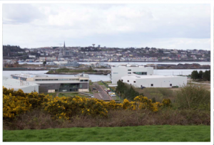 renewable energy and marine excellence that is the National Maritime College, the Beaufort Institute and Imerc were as developed as they are today. That of which we are so proud and of which Minister Coveney and so many third parties have spoken, both in written submissions and at this oral hearing.
The NMCI is special. It offers three full-time marine-related degree courses, a part-time degree in supply chain management,  Certificates of Competency for both engineering and deck roles in merchant shipping, specialised training for the Irish Naval Service and 88 commercial short courses in nine discreet shipping-related areas. In-house facilities are second to none and include a full size ship’s engine room, a fully instrumented engine control room, a range of workshops, laboratories, state of the art simulators, a sea survival pool, library, sports hall and an outdoor all
  weather pitch. In 2014, the NMCI signed a €2m training contract which will see the entire junior officer corps and junior engineers from the global shipping giant, Chevron, receiving skills training over four years. NMCI is also home to the Halpin Centre, the aim of which is to support maritime operations, maritime human factors and maritime mechatronics research and innovation in Ireland and overseas so that we can build a strong indigenous maritime technology business sector in Ireland.
The Beaufort Laboratory is a maritime multidiscipline research centre and the home of Imerc, the Ireland Maritime Energy  Research Cluster. At the 2009 oral hearing, Imerc was but a promise. Now, a real live partnership between the NMCI, the Cork Institute of Technology and the Irish Defence Forces, it is an on-the-ground reality. The concept of the Beaufort Laboratory is so new, so innovative and so global that sometimes it is difficult to understand. It is home to the MaREI Centre
  (Marine Renewable Energy Ireland), a research centre working with a range of national and international research and industry partners to come up with solutions to stumbling blocks in the marine and energy spheres.
The Beaufort justifiably boasts the Lir National Ocean Testing  Facility. This is one of the world’s largest wave testing facilities: four tanks at various depths, each fully equipped with measurement facilities, above and sub-surface motion sensors and test rigs for power take-off, grid connection, storage and subsea transmission. These wave tanks can produce waves up to 1.2 metres high, equivalent to the 30 metre waves experienced in the Atlantic off the west coast of Ireland. A new home for UCC’s Hydraulics and Marine Research Centre, here are decades of excellence in research on offshore engineering, coastal engineering, hydrodynamics and much more.
The Beaufort has also provided a new home to the Coastal and
Marine Research Centre, a dynamic branch of the UCC’s Environmental Research Institute specialising in marine ecology, seabed mapping, coastal processes and other marine and coastal thematic areas.
And then there is the Entrepreneur Ship, a base for start-up and  growing companies working in the maritime and energy sectors, with the on-hand support of research and academia, coupled with strong industry networking and connections. The Entrepreneur Ship concept is to nurture an innovative environment that yields intellectual property leading to start-up companies and jobs. The concept is working. The Beaufort has secured €30 million in funding already and contracts with many industry partners. As an example of some of the companies that are based there, Boston-based wave energy technology developer Resolute Marine Energy will create 80 new jobs with Imerc over the next five years. DARE Technology is building a prototype wind generator to be tested on board an Irish
  Naval Service vessel with which it is estimated over 1 million tonnes of carbon dioxide could be prevented annually. Exceedence Ltd. created five new jobs in marine renewable energy financial consultancy last year and plan to build to a staff of 30 to reach 4,500 companies globally who could benefit from Exceedence’s new software. Solo Energy is
working on reating sustainable and practical energy storage systems to deliver 100% renewable energy.

(This is the Taoiseach last year at the opening of the Beaufort Centre. The proposed incinerator site is in the background.)
You get the feel for the innovation and energy that is centred around this campus cluster, Mr. Inspector? Sometimes words alone do not express this. There is little doubt but that here is a slice of Ireland’s future. What sort of logic would see a juxtaposition of this against a contract incinerator on the opposite site of the road, using 100 year old moving grate technology, the core elements of which have not changed in the last 50 years?
Although the concept of a technopole in Cork was firmly established by the Cork Area Strategy Plan, we are beyond lucky that the NMCI began this new departure to the heavy industry focus that  previously was Ringaskiddy. In 2000, when the planning application for the NMCI was lodged (planning ref: 5570/00), Cork County Council did not want the planned facility to go to Ringaskiddy. The proposal included for accommodation of 400 students, of which 200 would be residential. That was in conflict with the industrial land use zoning and could present compatibility issues with the adjacent port. In fact, although acknowledging the evidenced need for some water frontage to serve the jetty, the County Council planners were concerned that putting the entire NMCI campus on this site might not be the best use of waterfront land. Had it not been for a push from the Department of Education, the NMCI might not have gone ahead in this location at all. As Mr. Noonan mentioned in his opening statement to this oral hearing on behalf of CHASE, the accommodation element was omitted because of potential compatibility issues with the Indaver site across the road.
The architect’s report submitted with the planning application for Imerc (planning ref: 11/5487) describes the Imerc site east of the NMCI as being one with “unique views over Cork Lower Harbour and the Lee Estuary …”, views which would deliver “a model environment for scientists”. What is now the Beaufort Laboratory was to be designed to create a strong sculptural presence, a marker for the entrance from the estuary to the Lower Harbour, a landmark building for research and innovation. At the time, Cork County Council’s Senior Executive Planner was concerned that at 20 metres high, the UCC proposal would create a “large building in the context of Ringaskiddy and a coastal location … [There would be] no hiding of this building in views across the water”. He wasn’t wrong, but his comments are worth considering in the context of the 50.7 metre building proposed by Indaver now being deemed acceptable by Cork County Council’s Senior Planner.
Imerc has a 10 year planning permission (planning ref: 14/5653) for site development works on more of their lands adjacent to the Beaufort Laboratory. The masterplan as described by Minister Coveney includes for the ultimate accommodation of 150 staff in 10 additional buildings and a central esplanade to act as a local social amenity.
Regardless of however cursorily it may have applied the World Health Organisation guidelines in its site selection of 1999 and despite what it may now say, I do not for one second believe that if Indaver was choosing a site for this proposed waste to energy plant today, it would choose this one literally across the road from these educational and innovative flagship centres of excellence.
Mr. Ahern is correct when he says that the landscape has changed. It has, but literally. Indaver operates five incineration facilities across  Europe. Two are in Belgium, both in big industrial estates. Two are in Germany, both in big industrial estates. The last is in County Meath. We in Ireland cannot even conceive of industrial estates the size of those accommodating the Indaver incinerators in Belgium and Germany. So in Ireland, I believe the most plausible
  equivalent is to put the incinerator in the shadow of something bigger. In the case of Meath, that something was the Platin cement facility where cement had been manufactured since 1938. (That little dot with the red circle around it is Indaver,
Carranstown.) In the case of Cork, the only real equivalents were  the Whitegate refinery and Irish Ispat. At the time, the levels of sulphur compounds in the Ispat’s gaseous emissions were so high that they solubilised on a misty day and would sting our eyes as we sailed past. But Whitegate was not available. Ringaskiddy was.

In her evidence to this oral hearing, Ms Patterson has explained how the World Health Organisation guidelines were “adopted as a conservative benchmarking tool for the Ringaskiddy site”. That “the conclusion of the 2008 assessment was that the Ringaskiddy site enjoys a favourable rating based upon the WHO Selection Criteria”. I have studied the 2008 in considerable detail and I still cannot identify any assessment therein where those selection criteria were applied before a location for the proposed waste to energy facility was identified. My clear understanding from both the 2008 and the 2016 EIS is that Step 1 in this process was to identify available areas within Cork Harbour with appropriate land zoning and reasonable accessibility to utilities.
Under current best practice, when a site for a landfill is being identified within a county, the entire area of that county is subject to  GIS analysis. The areas of karst limestone are blocked out in one colour. The areas within a certain radius of sensitive populations are blocked out with another. And so on, with each layer being laid one on top of the other, until only a relatively limited number of areas stand out as being ready for a closer look as to their suitability.
Had that correct approach been taken to the choice of the Indaver facility, Appendix A of Ms Patterson’s evidence would look very different. One cannot retrofit such issues as karst limestone, flooding and atmospheric unsuitability. The World Health Organisation’s first exclusionary factor in site selection for  hazardous waste management facilities are areas with unstable or weak soils, such as soft clay or clay-sand mixtures, or soils that lose strength with wetting or shock. You can see the soft lenses in this photograph of the cliff face at the Indaver site. You can
  see how, when they got wet, they collapsed outward. The water flowing out from the land is clearly visible at the base of the photograph. And this of course relates to the third World Health Organisation exclusionary factor pertaining to areas with saturated soils. This stuff is extraordinary, creating a plastic gooey mess.
The fourth exclusionary factor relates to areas of groundwater
recharge and areas with aquifers of significant or potential use. It is 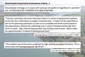 also worth noting that this exclusionary factor doesn’t just ask us to look at the geology under the site; it asks us to look at the site in question in the context of the regional geology. In his written and oral evidence to this planning hearing, Mr. Bennett’s depth of experience interpreted this on our behalf and on that of the Board. When the Beaufort building was being planned, McCullough Mulvin Architects reported on a similar geological/hydrogeological study of the land on the northern side of the L2545. Their findings were that:
‘Trial pits, boreholes and cores have been taken in a series of appropriate locations across the site, noted above as largely reclaimed land. A report will be submitted as part of this planning submission as soon as it is available and draft results based on site observations indicate the underlying rock is a karst limestone which dips from north to south. Silty sand overlays gravelly clay and dips east to west. Water levels are approximately 4 m below finished ground level.” (McCullough Mulvin, Planning ref: 11/5487).
Their findings add tremendous weight to Mr. Bennett’s conclusion that:
“The northern part of the site is underlain by high-yielding karstified limestone. This is structurally and hydrogeologically significant”.
I have already spoken of the special nature of the geology of Gobby  Beach in my written submission and indeed, it is to Gobby Beach that my engineering class was taken on field trips as part of our geology module. It is further confirmed by a wonderful book compiled by some eminent Cork geographers in 2006, the Atlas of Cork City6. Page 13 includes two plates illustrating some of the glacial features of Ringaskiddy, including the boulder clay cliff of what is now the Indaver site and Golden Rock, that mysterious erratic that maps from the 1700s indicate as being indisputably inland.
The World Health Organisation asks that hazardous waste facilities
would not be established in areas prone to flooding. This is exclusionary factor 5. To be fair, were tidal flooding all that were at issue with this site, it fair to say that it might be possible to engineer around it. The site is genuinely wet. The approach road and the western field are genuinely prone to tidal flooding. In preparing its flooding study for the Imerc site (planning ref: 14/5653) Arup  openly discusses flooding of Gobby Beach car park in both 2004 and 2014, flooding of the access road and flooding of what I believe is the western field. Their report quotes from a third party description of the 2004 flood event: “the surface of the car park has been significantly damaged and part of the sea wall has been washed away”. They confirm that this area corresponds to that of the car park which flooded in the 2014 flood event.
What is significant and frustrating to me as a third party is that the flooding issue is so played down in this case by comparison. The Executive Summary of Arup’s Flood Risk Assessment for Indaver simply states that:
“Sections of the road close to the Gobby beach car park are below this level and are therefore at risk of tidal flooding during a 1 in 200 year event … there is a risk of pluvial flooding to the L2545 and the low lying areas of the site during periods of heavy rainfall due to an insufficient drainage network and tide locking of the existing drainage outfall”.
Exclusionary criterion 7 is for areas like Cork Harbour which exhibit  such atmospheric conditions as thermal inversions. Images are included here to show the Board what a thermal inversion looks like when one is looking down on it (images taken from the high road between Passage West and Rochestown College) and what it looks like when one is in it (image taken from Cobh). Lest there be any
  further doubt that Cork Harbour does indeed experience thermal inversions, it is again categorically stated in that geographical bible, the Atlas of Cork City6. Page 17 reads:
“Cork’s valley location imposes a series of climate-related characteristics  on the city; for example, its problems with flooding which distinguishes from the climate of the wider region. The valley topography can, under specific air conditions, create air temperature inversions. This is particularly visible on cold, frosty mornings in the Lee and other valleys around the city, in the magical sight of ethereal layers of mist hovering in mid-air”.
Exclusionary factor 9 relates to areas of special natural resources,
such as the habitats of endangered species. It is indisputable that  the chosen site for this proposed facility is positively central to Cork Harbour, most of which is designated a Special Protection Area for birds. The Natural Impact Statement has been undertaken, devoting particular attention to Loughbeg, that portion of the Cork Harbour SPA which is closest to the Indaver site and to the Indaver site itself.
What is really important to remember about birds is that they are not static. And that is why the National Parks and Wildlife talks about the Cork Harbour SPA. They don’t talk about the Loughbeg SPA or the Monkstown Creek SPA or the Lough Mahon SPA. Rather, they talk about the Cork Harbour SPA because birds might feed in one area, roost in another, breed in yet another and so on. It is Cork Harbour as a whole that has been designated an internationally important wetland site. So it is very much only half the story that the Indaver site has been examined for avian species. Curlew, one of Cork Harbour’s Special Conservation Interest species, could be nesting in the Martello Tower field for example but, should the waste to energy plant be given planning permission, would never return there again. That a piecemeal approach to assessment is inadequate is confirmed by the National Parks and Wildlife26 who advise that
“… for some species, a mix of site-related and wider countryside measures are needed to ensure their effective conservation.”
The NPWS aims for the Cork Harbour SPA are straightforward:
- To maintain the favourable conservation condition of the non-breeding waterbird Special Conservation Interest species listed for the Cork Harbour SPA
- To maintain the favourable conservation condition of the wetland habitat at Cork Harbour SPA as a resource for the regularly-occurring migratory waterbirds that use it.
And in that straightforward aim, we are not doing so well.
The most recent assessment by the National Parks and Wildlife26 indicates clearly that the site conservation conditions for 18 out of  the 22 Special Conservation Interest species is unfavourable. In several cases, it is highly unfavourable. It shows that population trends for only four of the 22 Special Conservation Interest species are increasing. These are little grebe, grey plover and two of the godwits. Sadly, these trends are not reflected around the world. The pintail, for example, is on the increase both in Ireland and internationally but numbers have massively decreased in Cork Harbour.
  The shoveller and cormorant are the same: numbers of both species are increasing internationally but numbers of both species have dropped significantly in Cork Harbour. The National Parks and Wildlife concludes that in cases such as these where populations are stable or increasing at an all-Ireland level but where significant declines are seen at site level, it would be
“reasonable to suggest that site-based management issues may be responsible for the observed declining site population trends”.
I have studied many EIS’s for many developments proposed for Cork Harbour and don’t think I have ever yet seen one which predicted a negative impact on any aspect of the Cork Harbour SPA. So when the Board is conducting the Appropriate Assessment for the Indaver proposed development, I respectfully ask that it would satisfy itself in relation to every aspect of the multi-faceted ways by which this development could potentially pollute a range of environmental media. In this regard it is opportune to respectfully remind you, Mr. Inspector, of Dr. Good’s concern that the effect of nanoparticles in the marine environment would be addressed in the Natural Impact Statement.
I have already said much about exclusionary factor 11. This site that  Indaver seeks to build on is within the curtilage of a protected structure. Equally, Commdt David Browne speaking on behalf of the Department of Defence gave evidence last Friday of both the Irish Air Corps and the Naval Service concerns with respect to approaches by
 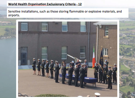 Air Corps helicopters into Haulbowline and Spike Islands. That covers exclusionary factor 12. Exclusionary factor 13 requires that hazardous waste facilities would not be established close to stationary populations. The definition of stationary population is
 open to debate, but it seems reasonable that it would include teaching and research institutions. Lest there be doubt, the Department of Justice continued to use Spike Island as a prison until 2004. Indaver clearly had no concern for exclusionary factor 13 when it purchased the site in Ringaskiddy in 2000.
And lest the site not yet have failed outright, the final exclusionary factor is one felt very deeply both by myself, many in this room and many more who have made written submissions to the Board. The World Health Organisation asks that we exclude areas which exhibit inequity resulting from an imbalance of unwanted facilities or from damage to a distinctive and irreplaceable culture or to people’s unique ties to a place.
This is Haulbowline Island in the earlier part of the 20th century. The  State built Irish Steel here in 1938. It ran at a loss until the State handed it to Lakshmi Mittal in 1996 for the sum of £1. It operated as Irish Ispat until it closed five years later. None of the environmental upgrades committed to by Mittal were undertaken during that time.
  It was one of the last industries in the country to be chased by the EPA for compliance with an Integrated Pollution Control licence.
This is Luck Beach, in and around 1984. It was what must have been  one of Ireland’s most beautiful places. In 1986, Angus was built just behind it.
Subsequently taken over by Hickson, this is Luck Beach in 1993. This  was regarded as one of the worst industrial accidents in the history of the Irish State.
And this is Ringaskiddy village in the 1930s – less than 100 years  ago.
ago.
This is Ringaskiddy village in the early 1970s.

And this is Ringaskiddy today, just 40 years later. The people of  Ringaskiddy and Cork Harbour generally have given so much, both to Cork County and to the Irish State. The country is glad of the revenue and proud of the industrial prowess. But without wishing to whinge, it would seem reasonable that the most basic of statutory obligations would be delivered to Cork Harbour as a priority. Yet, although statutorily charged with ambient air monitoring in accordance with the requirements of the CAFÉ Directive (Directive 2008/50/EC), the EPA has no monitoring station in Cork Harbour. After a nine-month monitoring event at Monkstown between 2007 and 2008, it advised that levels of particulate were high and that continuous monitoring was recommended10. There has been no monitoring since. I attach the text of a motion I raised in the Council Chamber in February 2016 in this regard. I also attach an analysis kindly prepared at my request by the National Cancer Registry of rates of a range of common cancers in each of the towns around Cork Harbour. We are told environmental factors have little relationship to cancer statistics. We are told they relate to exposures from many years ago. We increasingly learn of international research into the health effects of smaller particulates in the air we breathe.
(Examples at https://www.autismspeaks.org/science/science-news/largest-ever-study-autism-pollution-shows-strong-link-during-pregnancy; http://www.jlgh.org/JLGH/media/Journal-LGH-Media-Library/Past%20Issues/Volume%206%20-%20Issue%202/peterson6_2.pdf; http://www.ncbi.nlm.nih.gov/pmc/articles/PMC4019010/; https://www.sciencedaily.com/releases/2015/05/150521121049.htm)
Against this background and increasingly distanced from decision-making in what is our home, it is difficult for the people of Cork Harbour to often feel like little other than sacrificial guinea pigs.
So that is an analysis of the proposed site against 11 of the World Health Organisation’s exclusionary criteria for sites for hazardous waste facilities. Again, I may have missed it, but I simply don’t see analysis like that in either the 2008 or the 2016 versions of Indaver’s EIS. And although third parties have spoken many times about the failure of the site to meet so many of these criteria, I am hoping that by putting pictures with our words, we can indisputably illustrate the veracity of these words to the Board, finally closing the chapter on this nonsensical debate. I have already discussed Indaver’s justification of the Ringaskiddy site (Section 3.2.2 of the EIS) in my written submission to the Board.
The landscape has changed in another way too. The European waste landscape has changed.
We are all familiar with the European Waste Hierarchy. This was first enshrined in legislation in the 2008 Waste Framework  Directive14. The Directive lays down some basic waste management principles relevant to municipal waste:
- Waste must be managed without endangering human health
- Waste must be managed without harming the environment or adversely affecting the countryside and places of special interest
- Waste must be managed without causing a nuisance through noise or odour
- It introduced the polluter pays and extended producer responsibility principles
- It includes a target of 50% for reuse and recycling of certain waste materials from households
- It requires all member states to adopt waste management plans
- It requires all member states to adopt waste prevention programmes.
Until the 1990s, Ireland specialised in a disposal culture with a major focus on landfill. European waste legislation forced us to change as a society and the latest figures from 2013 indicate that we now recycle 40% of our municipal waste stream, incinerate 18% and landfill 42%21.
But there is general impatience in Europe with the ongoing relationship between waste generation and economic growth. In 2011, the European Commission introduced the Roadmap to a Resource Efficient Europe15 which, for the first time, truly recognised the connection between production process and waste generation and set about proofing economic growth for sustainability. It became incorporated into the most recent Circular Economy proposals16 of which Ms Fulton and Deputy O’Laoghaire spoke so eloquently.
As part of the Circular Economy, the 2008 Waste Framework Directive was to be revised. The new proposal was to introduce new targets for 2030:
- Recycling 65% of municipal waste by 2030
- Recycling 75% of packaging waste
- Reducing landfill to, at most, 10% of all waste
- And, critically in the context of this application, it tells us that “when waste cannot be prevented or recycled, recovering its energy content is (in most cases) preferable to landfilling … ‘Waste to energy’ can therefore play a role … but guided by the principles of the EU waste hierarchy”.
The Circular Economy package also proposed a revision of the Directive on Packaging and Packaging Waste18 (94/62/EC), a revision of the Directive on Landfill19 (1999/31/EC) and a revision of the Directive on electrical and electronic waste20 (2012/19/EU). And now finally the principle of mass conservation – matter is neither created nor destroyed, rather it is converted from one form into another – is to be enshrined through legislation.
Much has also happened on the Irish Waste policy scene since 2008 when Indaver made its last application for planning permission at this site. The most major of those major changes is that to which Mr. Ahern has referred in his evidence to this oral hearing: the Southern Region Waste Management Plan27. This Plan was produced as a result of the policy document, A Resource Opportunity8. This was then Minister Phil Hogan’s shake-up of Irish waste policy. It addressed the desirability of following the waste hierarchy and set about making Irish waste management planning a regional rather than a county affair. The over-riding principle of the new waste policy was, once again, the waste hierarchy. To encourage progress towards the primacy of the hierarchy, it calls for compulsory separate kerbside collection of organic waste and further examination of how Ireland may best set up an adequate domestic network of waste recovery facilities.
Three waste regions were created throughout Ireland. Each of these created a plan: the Southern Region Waste Management Plan, the Eastern Region Waste Management Plan and the Connaught Ulster Waste Management Plan.
Parties from both sides have repeatedly mentioned the Southern Region Waste Management Plan at this oral hearing. But on its own,
the Southern Region Waste Management Plan isn’t really relevant to this planning application. All three of the regional waste plans  regard thermal recovery facilities as being national facilities, not regional facilities. But what is truly relevant in the context of this application is how those regional waste plans address the waste hierarchy in their implementation of European waste policy.
Because the should the Indaver proposal go ahead, with its 10 year planning permission, 30 year operational period and possibility of extension for a further 30 years, it has the potential to lock in the management of Ireland’s waste for up to 70 years. That brings us to 2086.
The regional waste management plans span the period 2015 to 2021. So in order to plan for implementation of the waste hierarchy, they have to attempt to forecast the volume of waste which will be produced over that time. Based on a predicted increase in population and an increase in economic activity, the three regional waste plans collectively predict a 42% increase in Ireland’s municipal waste production by 2021. Indeed, our own Southern Region Waste Plan predicts a 50% increase in waste in the Southern Region of Counties Cork, Kerry, Limerick, Clare, Tipperary, Waterford, Wexford, Kilkenny and Carlow.
| 2012 | 2021 | |||||
| Household | Commercial | Total | Household | Commercial | Total | |
| South | 345,000 | 390,403 | 735,403 | 571,237 | 526,846 | 1,100,000 |
| East-Midlands | 681,449 | 568,873 | 1,25000 | 827,667 | 829,965 | 1,660,000 |
| Connaught-Ulster | 170,000 | 160,000 | 330,000 | 297,253 | 232,720 | 529,973 |
| Total | 2,315,403 | 3,289,973 | ||||
That does seem diametrically opposed to the top tier of the hierarchy, prevention, but is excused by a prediction for a concurrent significant population increase, particularly high in the Southern Region. But of course the corollary to these predictions are, as stated in the Plan, the challenge it will be to provide adequate domestic collection and treatment capacity.
Implementing policy, the Waste Plans look first at pre-treatment.  This is what happens to the waste after it is collected in preparation for its onward route. Then it looks at bring centres and civic amenity sites provided for by the local authority. Next, disposal and the Plans particularly note the EPA’s identified need for up to 277,000 tonnes of hazardous waste disposal11. No other particular targets identified, other than an acknowledgement of general support for the development of disposal capacity at existing landfills and for the availability of disposal capacity for industrial wastes.
Working its way back up the hierarchy, the Waste Plans talk next about recovery. Now before analysing what they say, it is critical to correctly understand the meaning of “recovery”. By definition, the principal result of a recovery operation is
“waste serving a useful purpose by replacing other materials which would otherwise have been used to fulfil a particular function or waste being prepared to fulfil that function in the plant or in the wider economy.” (European
So although not dealt with under the Recovery section of the Plans, pre-treatment clearly is recovery.
Recovery is divided into three sub-categories: preparing for re-use, recycling and other recovery. Thermal treatment, presuming it achieves the energy efficiency requirements of an R1 operation, falls into the “other recovery” category. You will note that the targets pertaining to the proposed revision of the Waste Framework Directive relate to recycling rather than to recovery generally.
That creates a problem. If I want to see how much of our municipal waste we recycle on our journey towards meeting those targets, I certainly cannot see it in any of the Regional Waste Management Plans. For the most part, statistics provided refer simply to “recovery”. There is no indication how much of that which is recovered is reused or recycled or sent for “other” recovery. Table 9.2 from the Southern Plan is a typical example of one such table. I know we have no facilities for the reprocessing of municipal dry recyclables in Ireland so I would like to see how much we export for that purpose. But our own Southern Region Waste Management Plan tells me that our latest data indicates Ireland as exporting 58% of total municipal waste recovered/recycled.
It is critical that we retain the understanding of the definition of recovery as advised by Europe. It encompasses reuse, recycling and other recovery with reuse and recycling to be prioritised over other recovery. Because after the Waste Plans discuss disposal, they next address the issue of recovery. And the first sub-section in that discussion pertains to thermal recovery. Subsequently, they continue to speak of biological treatment, other recycling and reuse, again, in that order. Prevention and the Circular Economy are issues not addressed until Section 19.
Section 16.4.5 of the three plans pertaining to thermal recovery are definitive in their requirement: there is a national need for additional thermal treatment for municipal waste over and above that active and pending of up to 300,000 tonnes. This figure is apparently based on projected waste arisings. There is no additional explanation as to how that figure is derived. You will recall that projected waste arisings indicate a worst-case scenario of 42% increase in waste produced nationally by 2021. You will juxtapose this presumption against the ongoing supremacy of the waste hierarchy which has waste prevention at its peak. You will also note the ethos behind the whole circular economy development: matter is neither be created nor destroyed but converted from one form into another.
Table 16.7 in each of the Waste Plans helpfully indicates the number of thermal recovery treatment facilities active and pending in the country. In this context, pending means that both planning permission to build and a Waste Licence to operate have been granted.
| Active (t) | Pending (t) | Total (t) | |
| Waste to energy (2) | 220,000 | 600,000 | 820,000 |
| Cement kilns (3) | 215,000 | 127,875 | 342,875 |
| Pyrolysis (1) | — | 65,000 | 65,000 |
| Total (6) | 435,000 | 792,875 | 1,227,875 |
I have omitted one column from the table: that which indicates that as but three of these facilities are currently active, only 28% of national thermal recovery capacity with both full planning permission and waste licence is being utilised. I would also point out that these figures pertain to EPA data from 2014. There have been changes even in the four years since. You will recall Mr. McDowell’s evidence to this oral hearing in relation to (I think) 5 cement kilns on the island of Ireland, all of which have a 20% substitution of SRF.
The only other quantified recovery in the Plans is for recycling of organic waste. That is deemed to be a regional function and the Southern Region Waste Management Plan touts for an additional 40,000 tonnes of treatment for this municipal waste fraction. No targets for recycling of materials or for reuse are specified at all.
In 2014, we had thermal treatment capacity for just about half the municipal waste being produced in the country. But as previously discussed, our current municipal recycling rate is approximately 40%. And if we are to hit the minimum circular economy targets that we will be bound to under European law, our municipal recycling rate will increase to 65%. That being the case, even with thermal treatment currently available, we already have sufficient capacity to treat the 35% residual.
| 2012 | 2021 | |
| Thermal recovery capacity (t) | 1,227,875 | 3,289,973 |
| MSW production (t) | 2,315,403 | 3,289,973 |
| Residual MSW @ 40% recycling | 1,389,242 | |
| Residual MSW @ 65% recycling | 810,391 | 1,151,490 |
This is the absolute best case scenario for thermal recovery. Firstly, this estimate assumes the larger figure for waste generation predicted by the Regional Waste Management Plans. Secondly, it assumes no waste prevention other than what is incorporated into the Waste Plans’ waste production forecasts. Thirdly, it assumes no increase in reuse, a critical element of recovery and sitting in a favoured position on the waste hierarchy. Fourth, it takes no account of additional recycling which may be due to meeting recycling targets for packaging waste of 75%. And lastly, it takes no account of that codicil in the circular economy’s proposed amendment to Article 11(a) in the 2008 Waste Framework Directive:
Article 11(a) Rules on the calculation of the attainment of the targets laid down in Article 11
- By way of derogation from paragraph 1, the weight of the output of any sorting operation may be reported as the weight of the municipal waste recycled provided that:
(a) such output waste is sent into a final recycling process
(b) the weight of materials or substances that are not subject to a final recycling process and that are disposed or subject to energy recovery remains below 10% of the total weight to be reported as recycled.
Also please note that attaining a recycling rate of 65% is not the tremendous mountain it may appear. At present, many homes are served by a two-bin system of kerbside collection. Simple implementation of a three-bin collection system with source separation of the organic fraction, accounting for 30 – 35% of the waste stream would deliver a massive leap towards this 2030 target.
What all this really shows is the intent behind the circular economy. Yes, incineration has a role to play but it is absolutely not to be planned for before superior stages in the waste hierarchy. Through our Regional Waste Management Plans, Ireland has done just that.
It is worth at this stage recalling that national policy aim in A Resource Opportunity:
“in keeping with the proximity and self-sufficiency principles, a key objective of waste management plans will be to ensure a sufficiency of waste management infrastructure within the state to manage municipal waste”.
It is quite clear that the word “recovery” is not mentioned anywhere in this objective. In fact, this objective could very sustainably be satisfied by a comprehensive source separation system of kerbside collection and drop-off collection, a similarly comprehensive pre-treatment network and the most sustainable destinations for the various waste fractions identified on a least-environmental-burden basis. National policy’s drive towards separate collection of the organic fraction of municipal solid waste is an excellent first step in this regard.
The next relevant objective of national policy pertains to the reform of the waste collection permitting system, the aim of which is to provide
“the opportunity for application of such conditions as are necessary to give effect to the waste hierarchy, reflecting the legal status of the hierarchy and the range of recovery options emerging, to promote self-sufficiency and to drive a move away from disposal and towards recovery”.
It is ironic that national policy refers to the legal status of the waste hierarchy whilst the Regional Waste Plans arising from that policy are, in my opinion, notably negligent in that regard. However, that aside, again comprehensive source separation of waste is the key to sustainable implementation of the waste hierarchy. Source separation is the friend of materials recycling. It is not the friend of waste to energy. Appendix 12b to the Response to Article 12 Compliance for W167-02 for the Carranstown facility includes a copy of a legal letter sent by Arthur Cox on behalf of Indaver to the EPA stating that the EPA’s pre-treatment requirement for municipal waste to incineration was wrong; that such a requirement should apply to landfill only.
It is also critical to note that this national aim is not for thermal recovery. It is specifically for a range of recovery options. Planning for an excess of thermal recovery has the real potential to preclude the viability of other recovery options further up the waste hierarchy.
Another relevant aim of national waste policy is that:
“Ireland requires an adequate network of quality waste treatment facilities. A review of recovery infrastructure will be completed by 31 December 2012 and the Environmental Protection Agency will advise on requirements in this regard. In particular, this will examine capacity for managing municipal waste in conformity with the principles of proximity and self-sufficiency”.
Not quite making the 31st December 2012 deadline, the EPA did submit the review of recovery infrastructure to the Department in April 201412. The resulting recommendations did not advise the provision of additional recovery capacity. Rather, the principle recommendation from the report was for changes to reporting which would enable the establishment of a live, comprehensive national capacity register of Ireland’s waste infrastructure dealing with all waste sources and types and publicly available to all. Interestingly, the EPA report concurs with my earlier conclusion when it says:
“The Government recommendations on the source separation of food waste from commercial enterprises and households and the national penetration of the ‘dry recyclables bin’ … suggest that as these requirements are implemented, the availability of residual mixed municipal waste for treatment will diminish”.
I am deliberately not discussing the references to proximity and self-sufficiency in this national policy aim so that I can address it together with the final aim of national waste policy directly relevant to considerations on this planning application. That is that:
“the national transfrontier shipment office, in determining if reasoned objections to shipments of waste should be made in accordance with article 11 of the Waste Shipments Regulation for mixed municipal waste shipments or other waste stream shipments, will have regard to national policy and the Waste Framework Directive, which are focused on maximising the resource which can be extracted from waste material and the development of a sustainable and self-sufficient approach to the end management of our waste in accordance with the proximity principle.”
“The proximity and self-sufficiency principles apply only to (i) waste passing to disposal and (ii) mixed municipal waste consigned to recovery. Furthermore, where applicable, these principles are not intended to generally restrict waste exports within the EU for the following reasons.
First, Section 37(A)(2) of the Waste Management Act makes clear that the self-sufficiency principle is primarily intended to ensure that the Community as a whole is self-sufficient.
Second, the Directive states that plans for national self-sufficiency must take into account national geographic circumstances. For example, the wording in the Directive takes account that some Member State boundaries do not reflect waste catchment areas and that some Member States are too small to warrant a full range of infrastructure.
Third, Section 37(A)(4) of the Waste Management Act states as follows:
“The principles of proximity and self-sufficiency shall not mean that the State has to possess the full range of final recovery facilities within the State.”
… It is in the national interest that export trade does continue. This is because the continuation of the export route acts as [a] form of safety valve that precludes the increase of (local, regional or national) prices within Ireland to inefficient/excessive levels to the detriment of consumers. In other words, the export route is likely to assist in ensuring that national waste management prices remain competitive.”
I appreciate Mr. Ahern has been quoted as saying we as a nation cannot continue to export our waste23 but these are not my words. This explanation of why the export route is critical in the context of a small country like Ireland is taken from Indaver Ireland’s submission to the preparation of the Regional Waste Management Plans in December 2013. I couldn’t have explained it better myself and agree entirely with the sentiment. Indaver finishes by saying:
“For these reasons, we believe that the future availability of export trade is consistent with the relevant legal framework and is in the interests of consumers of waste services.”
It’s odd how when we talk about self-sufficiency and the proximity principle, we so rarely look further than residual waste. If our concern with regard to exports relates to the potential loss of a resource, as expressed by the Department of the Environment, Community and Local Government9, then surely is it not to the recyclables streams our attention should be diverted? These are the high value streams; those that are regarded as raw materials. Yet most of our source separated municipal paper, cardboard, glass and metals are exported.12 If our concern with regard to exports relates to the potential loss of jobs, again it is to that stream we need to look. It is in preparing and processing these streams that there is significant job creation. The SITA estimates for recycling are quoted as being 1 direct job per 1,590 tonnes of annual waste and 1 indirect job per 1,240 tonnes of annual waste9. By comparison, the job creation associated with Indaver’s proposed residual waste facility in Ringaskiddy is 1 direct job per 3,810 tonnes of waste.
Yet our attention so often turns to the residual stream. Much of Europe is loving our residual municipal waste at the moment. The reality is that at the moment, European countries are exporting more waste than ever24. European Environment Agency Executive Director describes this trade as being seen to be “largely positive, as material is often transported to places where it can be better used”1.
From a sustainability point of view, there is of course an emissions cost to transport. But a report carried out for the European Commission in 2001 (reported on to the Department of the Environment, Community and Local Government in 20159), concluded that:
“Overall, emissions of greenhouse gas associated with transportation of waste, residues and recovered materials are small in comparison with the much larger greenhouse gas fluxes in the system, such as those related to avoided energy/materials, landfill gas emissions and carbon sequestration:.
There is of course the loss of indigenous energy. With implementation of the circular economy principles, this energy will of course not be renewable because the biodegradable fraction of municipal waste will be separated at source and recycled in accordance with the waste hierarchy. (Indeed, as an aside, it would be in my opinion much more in our line to develop sustainable markets for the end use of compost and digestate materials from this recycling than to be planning for yet further thermal treatment of residual waste.) There is far more energy to be saved from the comprehensive application of steps further up the waste hierarchy than there is from recovery of energy through the burning of waste. One energy conservation analysis determined that for 24 out of 25 solid waste materials, recycling saves more energy than is generated by incinerating mixed solid waste in an energy-from-waste facility25. To be fair, there’s no genius here. If it was otherwise, waste-to-energy would be at the top of the waste hierarchy rather than second from the bottom.
We will need to export residual municipal waste as we implement the principles of the circular economy. Waste prevention is a task that will take years to achieve in a meaningful way. As a nation, we are very much feeling our way around the concept of reuse. We haven’t yet even found ways to quantify what we’re reusing. Separating materials from the waste stream is all well and good but, as mentioned above, finding markets for that which is processed is a very different story. So it will take time to advance towards a more sustainable system of waste management.
In that time, it is my opinion that it is encumbent on us to use our residual waste in the most energy-efficient way possible. To this end, it will be necessary to take into account the efficiency of the facility to which we are sending that waste, whether at home or abroad. In truth, it often follows that the facilities with the lowest gate fees are those which are most efficient; they are the ones that have well developed markets for steam, that which is widely regarded as the most valuable product from waste-to-energy.
To be honest, in this context, to be sitting here for a third time in front of a planning inspector spending our time and taxpayers’ money debating the merits or otherwise of a proposed incinerator to produce energy at 25 – 30% conversion efficiency at best whilst using 5.4 cubic metres of fresh water each hour to assist in cleaning gases that would otherwise poison humans and the environment is little short of ludicrous.
Incineration is always a waste disposal activity unless it is proven otherwise. This was the ruling of two important European Court of Justice cases in 2003. (the Belgian Cement Kilns, Commission versus Germany and the Strasbourg Incinerator, Commission versus Luxembourg.) They deemed that if an operation is to be a recovery operation, (i) its main purpose must be the generation of energy, (ii) the amount of energy generated, recovered and effectively used must be greater than the amount of energy consumed and (iii) that the principal use of the waste is fuel. So, for example, the use of waste in a cement kiln is always recovery because it is replacing a fossil fuel. But an incinerator is designed to burn waste. So it is a disposal operation. To be considered a recovery operation, it must prove that it meets these criteria2. To this end, the R1 formula was devised.
I am not sure how mamy iterations of the R1 calculation there have been for the proposed Ringaskiddy facility throughout this oral hearing. But all I do know is that for Indaver to have even been permitted by the Board to lodge a planning application for a “resource recovery facility” without first proving that the facility is indeed for recovery and not disposal is entirely contrary to the European Court of Justice rulings. Mr. Singleton identified the need for the R1 calculation in his assessment of the planning application. We are at this hearing for over a week now and he is still requesting – to date in vain – the envelope of wastes proposed for acceptance at the facility and their associated calorific values. At the last oral hearing for the 2008 planning application, I distinctly recall the same reticence on the part of Indaver to produce the R1 formula as it would apply to the Ringaskiddy facility. I don’t know, Mr. Inspector, but if I knew I was a borderline disposal facility and that it was a real issue I was only generating electricity without using the heat, I’d be jumping up and down waving my R1 formula like a badge of honour. But Indaver is not.
If the proposed facility were a real hazardous waste incinerator, achieving the requisite R1 would not be so much of a challenge. Solvents and their ilk are delightfully high in calorific value. But let’s be truthful: this isn’t a real hazardous waste incinerator. The 24,000 tonnes of hazardous waste proposed for the feedstock is what I affectionately describe as the “stupid” wastes, the dregs of manufacturing and the household streams. Of course they are stupid in terms of energy value; they are not at all stupid in terms of the gate fee their acceptance will realise. In my opinion, the magnificence of including some hazardous waste in the input stream is that, together with the 10,000 tonnes accepted annually at the Carranstown facility, Indaver would have tied up 34,000 tonnes of the EPA’s recommended 50,000 tonne national hazardous waste incinerator. Not merely might it put off proposals for the construction of a dedicated hazardous waste incinerator, the project can claim that it is answering the requirements of the National Hazardous Waste Management Plan11. In the meantime, Indaver will continue to export the valuable high-end hazardous streams.
The first National Hazardous Waste Management Plan13 had a clear recommendation for Ireland to become self-sufficent in hazardous waste recovery and disposal capacity. With regard to thermal treatment, it advised that:
“a thermal treatment disposal facility for the management of hazardous waste currently exported for disposal is required if Ireland is to become self-sufficient in hazardous waste management”.
In just 13 years, the current National Hazardous Waste Management Plan11 has adopted quite a different attitude. It notes that because of the open and competitive European waste market, policies of self-sufficiency and proximity have been largely abandoned in other Member States. Its recommendation is therefore to:
- Keep under review the provision and facilitation of hazardous waste treatment capacity and make recommendations ont eh appropriate economic or other instruments necessary for such capacity to be provided, either by the public or private sector
- Develop national policy or guidance to direct the control of hazardous waste shipments in order to facilitate self-sufficiency in hazardous waste treatment where this is technically, economically, strategically and environmentally advisable.
Why this is worth noting in particular is not merely for its content, but also for its illustration of the rapidly changing market that is waste and therefore the risks inherent to locking national waste into a single treatment facility or collection of facilities.
Although the National Hazardous Waste Management Plan does commit to not recommending one technology over another, it does point out that the promotion of combustion in cement kilns and landfil of certain wastes if no other option is available should be facilitated in the interest of reducing exports by using existing infrastructure. It is of course paramount that any such facility would be operated to achieve protection of human health and the environment.
In this regard, it is interesting to note that in December 2015 that Irish Cement’s manufacturing facility at Platin has applied to the EPA for an increase in the alternative fuels it is permitted to accept. Currently burning 120,000 tonnes of waste as a replacement for fossil fuel in one kiln, it has sought an IPC licence to increase that intake by 480,000 tonnes to 600,000 tonnes per year in two kilns. Irish Cement estimates that this will reduce the requirement for 210,000 tonnes of imported fuel each year and will also reduce the carbon dioxide footprint by 230,000 tonnes each year. Because it constitutes fuel substitution, burning in a cement kiln is automatically defined as recovery. The Platin proposal is not isolated. To this end, Mr. Inspector, I refer you to the Cement Manufacturers Ireland’s submission to the formulation of national waste policy in 20113.
The feedstock the Platin facility used last year appears to have been very similar to that proposed for the Indaver Ringaskiddy facility. Its non-hazardous elements comprised municipal dry recyclables, metals, mixed municipal solid waste, sludges from water clarification, edible oil and fat and wood, construction and demolition waste. It also accepted hazardous feedstock, including engine, other oils and oil filters, contaminated packaging, absorbents, filter materials and protective clothing, construction materials containing asbestos, light fittings and other waste electrical and electronic equipment. Whether these should be burned or not is a different argument and not for now. But it appears to be much the same feedstock for which the Ringaskiddy facility would be competing merely serves to heighten previously expressed fears with regard to over-provision of thermal recovery facilities in advance of any real attempt to tackle those critically important steps towards sustainability in the upper echelons of the waste hierarchy.
Mr. Inspector, the Regional Waste Management Plans which the Indaver proposal for Ringaskiddy now claims to respond to is based on waste statistics from 2010, 2011 and 2012. That makes them, at best, four years out of date. The EPA has said that 2014 hazardous waste statistics will be released this summer whilst the 2014 municipal waste statistics are still being processed. This is not to criticise the EPA in any way in this regard but to emphasise the ludicrousness of planning for 70 years from now with data that is already four years old. The Regional Waste Management Plans are likely to be out of date by the time the proposed Indaver facility would even be built. That is no way to plan for a national waste facility.
Mrs. Bowen put questions to the oral hearing about bottom ash to Bottlehill yesterday. You pointed out that Bottlehill is not part of this planning application. You were of course correct, Mr. Inspector. It is not. But what sort of piecemeal way is this to be planning what is purported to be a strategic national facility? Up to one third of residual material coming from the proposed Ringaskiddy waste facility would be bottom ash. It is responsible to plan from the outset for the best available technology for dealing with the treatment and/or disposal of residuals from a national facility. Otherwise, one cannot make any stab at sustainable waste management.
Do you remember the Race Against Waste, Mr. Inspector? It occurs to me that this is the Race For Waste. Irish Cement wants it, the other cement manufacturers want it, Cadence EnvironPower wants it in Gortadroma, someone else just might want it in Bottlehill and Indaver wants it for Ringaskiddy.
I want to register my abject disgust at this, our approach to strategic national waste planning. Planning for a national facility of such critical importance to Ireland’s response to European legislation, the optimisation of our country’s resources and our contribution to global sustainability should not be driven by commercial greed. It should be carefully planned, government-driven and always, but always, ignited by a common and informed drive towards economic, societal and environmental sustainability.
References:
- At: http://www.eea.europa.eu/highlights/eu-exporting-more-waste-including.
- Beyer and Hansen (2003). Incineration as Recovery and Disposal of Waste. Analysis and interpretation of the judgements of the European Court of Justice C458/00 and C228/00. Policy Brief for the EP Environment Committee EP/IV/A/2003/09/01.
- Cement Manufacturers Ireland (2011). Towards a National Waste Policy: National Benefits of Incorporating Ireland’s Cement Manufacturing Infrastructure into Future National Waste Policy. A submission to the Department of the Environment, Community and Local Government.
- Cork County Council (2007). Cork County Draft Landscape Strategy.
- Cork County Development Plan 2014.
- Crowley et al. (2006). Atlas of Cork City.
- Department of Environment, Heritage and Local Government (2004). Architectural Design Guidelines – Guidelines for Planning Authorities. Guidance on Part IV of the Planning and Development Act 2000.
- Department of the Environment, Community and Local Government (2012). A Resource Opportunity – Waste Management Policy in Ireland.
- Department of the Environment, Community and Local Government (http://www.environ.ie/sites/default/files/migrated-files/en/Publications/Environment/Waste/FileDownLoad%2C43707%2Cen.pdf.
- Environmental Protection Agency (2008). Ambient Air Monitoring At Cork At: http://www.epa.ie/air/quality/data/ch/#.VyBdsmPJTaY
- Environmental Protection Agency (2014). National Hazardous Waste Management Plan 2014-2020.
- Environmental Protection Agency (2014). National Municipal Waste Recovery Capacity. An Assessment for the Department of Environment, Community and Local Government.
- Environmental Protection Agencyt (2001). National Hazardous Waste Management Plan.
- European Commission (2008). Directive 2008/98/EC on waste.
- European Commission (2011). Roadmap to a Resource Efficient Europe. COM (2011)571.
- European Commission (2015). Closing the Loop – An EU Action Plan for a Circular Economy COM(2015)614.
- European Commission (2015). Proposal for a revised directive on waste. COM(2015)595.
- European Commission (2015). Proposal for a revised directive on packaging waste. COM(2015)596.
- European Commission (2015). Proposal for a revised directive on landfill. COM(2015)594.
- European Commission (2015). Proposal for a revised directive on electrical and electronic waste. COM(2015)593.
- Eurostat, 2016. At http://ec.europa.eu/eurostat/documents/2995521/7214320/8-22032016-AP-EN.pdf/eea3c8df-ce89-41e0-a958-5cc7290825c3.
- Indecon (2008). Socio-Economic Impact of Ringaskiddy Port Redevelopment. On behalf of the Port of Cork.
- Irish Examiner, 18th April 2016.
- Jofra Sora (2013). Incineration Over-Capacity and Waste Shipping in Europe. Commissioned by the Global Alliance for Incinerator Alternatives (GAIA).
- Morris (1996). “Recycling versus incineration: an energy conservation analysis”. In Journal of Hazardous Materials, p. 277-293, Vol. 47.
- National Parks and Wildlife Service (20914). Conservation Objectives Supporting Document – Cork Harbour Special Protection Area, Site Code 4030.
- Southern Region Waste Management Office (2015). Southern Region Waste Plan.
- Ecorys (2012). Economic Value of Ireland’s Historic Environment. On behalf of the Heritage Council.
- Scott Tallon Walker Architects Consortium (2012). Masterplan for Spike Island.